Argentine Provinces outlines quiz
Only the shape is shown, with no map around it. Can you tell which province it is? A great way to really learn Argentine Provinces.
Top scores
- The five fastest 100% rounds on this quiz.
Finish with 100% and post your time to get on the board – here or in full screen. All leaderboards
Your next quiz
 Australian States quiz8 states & territories
 Indian States quiz36 states & territories
What's on this map
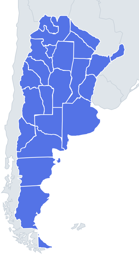
All 24 Argentine units shown as outlines, one at a time. Many provincial borders follow rivers on the east and the crest of the Andes on the west, while the borders in between are often straight survey lines. That mix gives each province a rough edge on one side and a ruler-straight one on another, and those edges are the best clues.
A handful of shapes are unmistakable. Buenos Aires is a big wedge with the Atlantic coast and the River Plate estuary on its east side. Tierra del Fuego is the triangle-shaped half of an island cut off by a perfectly straight north-south line, the border with Chile. Misiones is a narrow finger pointing north-east between two rivers. Buenos Aires City is a tiny shape with the River Plate along its east side.
The places people miss
- La Pampa – almost a perfect rectangle with straight edges on all sides except the south, where it follows the Colorado River.
- Chubut – a wide rectangle with straight north and south borders and a jagged Atlantic coast, including the Valdés Peninsula sticking out at the top right.
- Santa Cruz – the biggest Patagonian shape, broad and squarish, with a ragged Andean western edge.
- Río Negro vs Chubut – Río Negro's northern edge slopes along the Colorado River and its coast is the short curve of the San Matías Gulf; Chubut is taller and blockier.
- Tucumán – the smallest province, a compact little shape with no coast and no river edge.
- Salta – a large, irregular claw that wraps around Jujuy on the east and south.
- Corrientes vs Entre Ríos – both bounded by rivers. Corrientes is the upper, larger one; Entre Ríos is the "island" hemmed in by the Paraná and Uruguay rivers, with a pointy southern tip.
- Santiago del Estero – a big landlocked block in the north-centre with mostly straight edges.
How to learn it
- Start with the five easy shapes: Buenos Aires, Tierra del Fuego, Misiones, Buenos Aires City and La Pampa.
- Then do the Patagonian column top to bottom, comparing the rectangles.
- Leave the Northwest for last; Salta's claw is the key, because Jujuy sits inside it.
- Similar-sized provinces are mixed in as wrong answers, so look for a coastline, a river edge or a straight line before you guess.
Guides that help with this
- Oceans, seas, rivers and mountainsThe physical map: seas around each continent, the big rivers and ranges.
- Why you forget countries – and how spaced repetition fixes itThe forgetting curve, and how the Mistake Bank and flashcards use it.
- Flags that look alike (and how to tell them apart)Chad or Romania? Australia or New Zealand? The flag pairs that cost quiz points.
How it works
Each question shows one outline and four names. Similar-sized provinces are mixed in, so it gets tricky.
All 24 provinces in this quiz
Buenos Aires, Buenos Aires City, Catamarca, Chaco, Chubut, Córdoba, Corrientes, Entre Ríos, Formosa, Jujuy, La Pampa, La Rioja, Mendoza, Misiones, Neuquén, Río Negro, Salta, San Juan, San Luis, Santa Cruz, Santa Fe, Santiago del Estero, Tierra del Fuego, Tucumán.