Finnish Regions outlines quiz
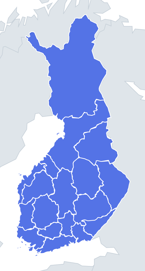
Only the shape is shown, with no map around it. Can you tell which region it is? A great way to really learn Finnish Regions.
Top scores
- The five fastest 100% rounds on this quiz.
Finish with 100% and post your time to get on the board – here or in full screen. All leaderboards
Your next quiz
 Polish Voivodeships quiz16 voivodeships
 Dutch Provinces quiz12 provinces
 Swedish Counties quiz21 counties
What's on this map
All 18 mainland Finnish regions, shown one at a time as a bare shape. Each question offers four names, and the wrong answers are regions of similar size, so you cannot simply guess "the big one". The sizes vary enormously: Lapland alone covers nearly a third of the country, while Central Ostrobothnia, Kymenlaakso and Tavastia Proper are each less than a fifteenth of Lapland.
Two features give most shapes away. Coastal regions have a ragged western or southern edge, broken by islands and inlets left by the ice sheets; the land is still slowly rising since the last ice age. Regions on the eastern side have long, fairly straight edges where they meet the Russian border. Six regions touch Russia: Lapland, Northern Ostrobothnia, Kainuu, North Karelia, South Karelia and Kymenlaakso.
The lake regions in the middle are the hardest. Their borders wander around lakes such as Päijänne and Saimaa, and the shapes often have holes or bites taken out of them where water forms the edge.
The places people miss
- Lapland – easy by size, but look for the "arm" (Käsivarsi) poking out to the northwest between Sweden and Norway. Nothing else has it.
- Northern Ostrobothnia – the second-largest region, stretching from the coast at Oulu all the way to the Russian border. A wide band running across the country is almost always this one.
- Ostrobothnia vs Central Ostrobothnia – both are coastal. Ostrobothnia is a long, narrow strip with a very broken coast around Vaasa and the Kvarken islands; Central Ostrobothnia is a short, compact wedge.
- Uusimaa – long and thin along the south coast, with an archipelago edge on the Gulf of Finland side.
- Kainuu vs North Karelia – both have a straight eastern border with Russia. Kainuu is squarer and sits further north; North Karelia is rounder and bulges east.
How to learn it
- Run Find on the map first so each shape has a place in your head before you see it alone.
- In Outlines mode, ask two questions for each shape: does it have a coast, and does it have a straight Russian edge?
- Learn the three giants (Lapland, Northern Ostrobothnia, Kainuu) and the four coastal strips first, then the lake country.
- Let the Mistake Bank collect your misses and replay until 18 of 18 is routine.
Guides that help with this
- Oceans, seas, rivers and mountainsThe physical map: seas around each continent, the big rivers and ranges.
- Why you forget countries – and how spaced repetition fixes itThe forgetting curve, and how the Mistake Bank and flashcards use it.
- Flags that look alike (and how to tell them apart)Chad or Romania? Australia or New Zealand? The flag pairs that cost quiz points.
How it works
Each question shows one outline and four names. Similar-sized regions are mixed in, so it gets tricky.
All 18 regions in this quiz
Central Finland, Central Ostrobothnia, Finland Proper, Kainuu, Kymenlaakso, Lapland, North Karelia, Northern Ostrobothnia, Northern Savonia, Ostrobothnia, Päijänne Tavastia, Pirkanmaa, Satakunta, South Karelia, Southern Ostrobothnia, Southern Savonia, Tavastia Proper, Uusimaa.