Brazilian States quiz
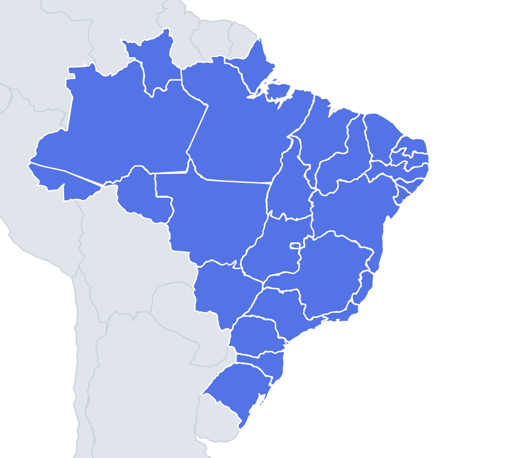
Can you find all 27 states on the map? Tap the right place, see how fast you can reach 100%, and practise the ones you missed until you know them all.
Top scores
- The five fastest 100% rounds on this quiz.
Finish with 100% and post your time to get on the board – here or in full screen. All leaderboards
Your next quiz
 Argentine Provinces quiz24 provinces
 Australian States quiz8 states & territories
What's on this map
Twenty-six states and the Federal District, in five regions. The North is the huge block: Amazonas and Pará in the middle, Roraima and Amapá on the top edge, Acre and Rondônia in the south-western tail, Tocantins on the east. The Northeast is the dense coastal arc: Maranhão, Piauí, Ceará, Rio Grande do Norte, Paraíba, Pernambuco, Alagoas, Sergipe and then big Bahia.
The Centre-West is Mato Grosso, Mato Grosso do Sul and Goiás, with the Federal District (Brasília) inside Goiás. The Southeast is Minas Gerais, Espírito Santo, Rio de Janeiro and São Paulo. The South is Paraná, Santa Catarina and Rio Grande do Sul, top to bottom.
Anchor on Amazonas, Bahia, São Paulo and Rio Grande do Sul, then fill the Northeast arc clockwise from Maranhão.
The ones people miss
- Piauí vs Maranhão – Maranhão is west with São Luís on the coast; Piauí is the one with only a sliver of coastline and an inland capital, Teresina.
- The eastern corner – going clockwise from Ceará: Rio Grande do Norte, Paraíba, Pernambuco, Alagoas, Sergipe. Sergipe is the smallest state.
- Roraima vs Rondônia – Roraima is on top, Boa Vista; Rondônia is in the south-west next to Bolivia, Porto Velho.
- Amapá – the state north of the Amazon mouth, capital Macapá on the equator.
- Tocantins – split from Goiás in 1988; it is the long state between Pará and Bahia, capital Palmas.
- Mato Grosso vs Mato Grosso do Sul – "do Sul" is the southern one, Campo Grande; the northern one has Cuiabá.
How to learn it
- Start with Study the map and learn the Northeast arc as one clockwise sequence.
- Play Find on the map until you hold 25 or more; the Mistake Bank will fill with the small Northeast states.
- Capitals is a long list here, so use flashcards for the ones that do not share the state name.
- Outlines mode is a good follow-up; Minas Gerais, Bahia and Pará have very recognisable shapes.
- Done is a clean Name them all and a sudden-death streak of 27.
Guides that help with this
- Why you forget countries – and how spaced repetition fixes itThe forgetting curve, and how the Mistake Bank and flashcards use it.
- Using Quiz the Map in the classroomWhich quizzes fit which age, live class games, printable maps.
- Flags that look alike (and how to tell them apart)Chad or Romania? Australia or New Zealand? The flag pairs that cost quiz points.
How to play
A name appears at the top. Tap that place on the map. You get three tries: green means first try, yellow second and orange third. After three misses the right place flashes. Tiny places get a circle so they are easy to hit, and you can zoom with two fingers or the mouse wheel.
Want a harder test? Try Name them all (type every state you can remember before the clock runs out) or Sudden death (one mistake and the game is over).
All 27 states
| State | Capital |
|---|---|
| Acre | Rio Branco |
| Alagoas | Maceió |
| Amapá | Macapá |
| Amazonas | Manaus |
| Bahia | Salvador |
| Ceará | Fortaleza |
| Espírito Santo | Vitória |
| Federal District | Brasília |
| Goiás | Goiânia |
| Maranhão | São Luís |
| Mato Grosso | Cuiabá |
| Mato Grosso do Sul | Campo Grande |
| Minas Gerais | Belo Horizonte |
| Pará | Belém |
| Paraíba | João Pessoa |
| Paraná | Curitiba |
| Pernambuco | Recife |
| Piauí | Teresina |
| Rio de Janeiro | Rio de Janeiro |
| Rio Grande do Norte | Natal |
| Rio Grande do Sul | Porto Alegre |
| Rondônia | Porto Velho |
| Roraima | Boa Vista |
| Santa Catarina | Florianópolis |
| São Paulo | São Paulo |
| Sergipe | Aracaju |
| Tocantins | Palmas |