Name all 13 French Regions
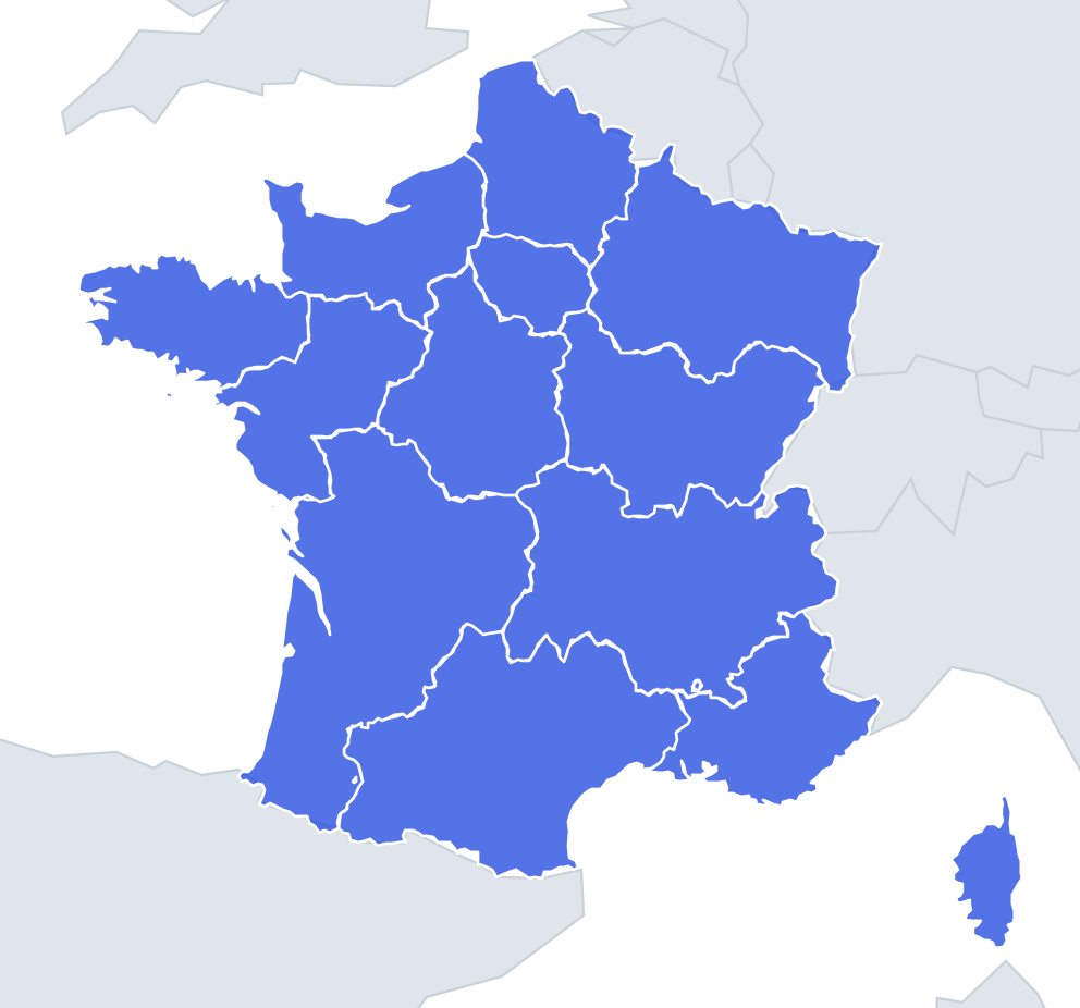
No map hints and no multiple choice: just type every one you can remember. Each correct answer lights up on the map, and the clock keeps running until you give up or get all 13.
Top scores
- The five fastest 100% rounds on this quiz.
Finish with 100% and post your time to get on the board – here or in full screen. All leaderboards
Your next quiz
 Spanish Regions quiz16 regions
 Italian Regions quiz20 regions
What's on this map
Thirteen regions of metropolitan France – the twelve on the mainland plus Corsica. This is the map since 2016, when the old 22 regions were merged, so old names like Aquitaine, Picardy, Alsace, Burgundy and Languedoc-Roussillon will not count. They now live inside Nouvelle-Aquitaine, Hauts-de-France, Grand Est, Bourgogne-Franche-Comté and Occitanie.
The new names are worth understanding, because each one tells you where it is. Hauts-de-France means "the upper part of France" – the top of the map. Grand Est is simply "the Great East". Occitanie is named after Occitan, the langue d'oc once spoken across the south, where "oc" was the word for yes. Nouvelle-Aquitaine revives Aquitania, the Roman province of the southwest. Île-de-France, the "island of France", is the old royal heartland around Paris, ringed by rivers such as the Seine, Marne and Oise.
Three regions are best typed in their English form: Brittany (Bretagne), Normandy (Normandie) and Corsica (Corse). The rest are usually written in French even in English.
The places people miss
- Provence-Alpes-Côte-d'Azur – the longest name, often shortened to PACA. You need all three parts: Provence, the Alps and the Riviera coast.
- Bourgogne-Franche-Comté – Burgundy plus Franche-Comté. People type "Burgundy" and wonder why it fails.
- Auvergne-Rhône-Alpes – the merger of Auvergne and Rhône-Alpes, so three place names in one.
- Centre-Val de Loire – note the hyphen after Centre but none inside "Val de Loire".
- Corsica – forgotten because it floats off the map; it has its own special status as a territorial collectivity.
How to learn it
- Sweep clockwise from the Channel: Hauts-de-France, Grand Est, Bourgogne-Franche-Comté, Auvergne-Rhône-Alpes, Provence-Alpes-Côte-d'Azur, Corsica.
- Then up the west side: Occitanie, Nouvelle-Aquitaine, Pays de la Loire, Brittany, Normandy.
- Finish in the middle: Île-de-France and Centre-Val de Loire.
- Count as you go – six, then eleven, then thirteen – so you know immediately which group is missing a name.
- Done is 13 of 13 in under a minute.
Guides that help with this
- Oceans, seas, rivers and mountainsThe physical map: seas around each continent, the big rivers and ranges.
- Why you forget countries – and how spaced repetition fixes itThe forgetting curve, and how the Mistake Bank and flashcards use it.
- Flags that look alike (and how to tell them apart)Chad or Romania? Australia or New Zealand? The flag pairs that cost quiz points.
How it works
Type a name and press enter. Spelling is forgiving: accents, capital letters and common alternative names are all accepted. When you stop, the ones you missed are shown on the map so you know which to practise next time.
Most people get well under half on the first try. Play the map quiz a few times first, then come back and see how many you can name.
Answer list (13 regions)
Show all 13 answers (spoilers)
- Auvergne-Rhône-Alpes
- Bourgogne-Franche-Comté
- Brittany
- Centre-Val de Loire
- Corsica
- Grand Est
- Hauts-de-France
- Île-de-France
- Normandy
- Nouvelle-Aquitaine
- Occitanie
- Pays de la Loire
- Provence-Alpes-Côte-d'Azur