South America Map: All 12 Countries and Capitals, With a Trick for Each
On this page
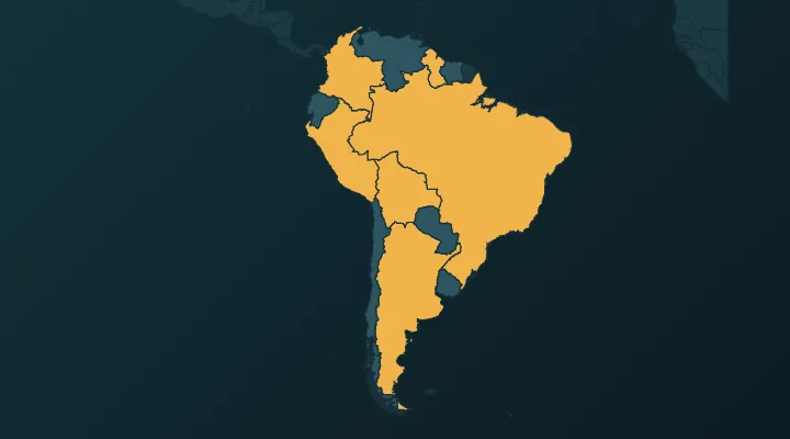
South America is the friendliest continent to learn. It has only 12 independent countries, most of them big enough to click without zooming, and the capitals follow a few clear patterns. The hard parts are a small handful: the three Guianas on the north coast, the Bolivia–Paraguay pair in the middle, and Bolivia's two capitals. This guide goes around the continent in an order that sticks, so that by the end you can place every country and name every capital.
Why 12?
South America has 12 sovereign countries. Two other places on the map are not countries, which is why they don't appear in our South America quiz:
- French Guiana on the north coast is part of France – a full French region, inside the EU, using the euro. Its main town is Cayenne.
- The Falkland Islands in the South Atlantic are a British overseas territory, claimed by Argentina as the Islas Malvinas.
Start with the giant
Brazil – Brasília. Brazil covers almost half of South America's land (about 48%) and borders every other country on the continent except two: Chile and Ecuador. Its capital is not Rio de Janeiro or São Paulo but Brasília, a planned city built on the central plateau and opened in 1960 to pull development inland. Rio was the capital before that.
Memory hook: Brasília is in the middle of Brazil because it was built to pull people into the middle.
Once Brazil is placed, everything else is "around Brazil". The order below goes clockwise from the north-east: the Guianas, the Andes from top to bottom, the landlocked middle, and the River Plate.
The north coast: the three Guianas
These three are the most-missed part of the continent because they are small, squared off and side by side. Learn them as a set.
Guyana – Georgetown. The westernmost of the three, next to Venezuela. It is the only country in South America with English as its official language, a legacy of British rule (it was British Guiana until 1966). Georgetown is named after King George III. Memory hook: English-speaking Guyana, capital named after an English king.
Suriname – Paramaribo. The middle of the three, and the smallest country on the continent (about 163,000 km²). It was a Dutch colony – at the 1667 Treaty of Breda the Dutch kept it and let the English keep New Amsterdam, today's New York – and Dutch is still the official language. Paramaribo, whose wooden colonial centre is a UNESCO World Heritage Site, is on the coast, near the mouth of the Suriname River.
French Guiana sits east of Suriname, against Brazil. Not a country, but you need it to see the pattern.
Hook for the order, west to east: English, Dutch, French – Guyana, Suriname, French Guiana.
The Andes, north to south
The Andes run down the whole west side of the continent, and four of the capitals here sit high in them. Learning which capitals are in the mountains and which are on the coast helps you remember where they are.
Venezuela – Caracas. The top of the continent, on the Caribbean coast, between Colombia and Guyana. Caracas sits in a mountain valley about 900 metres up, just a ridge away from the sea.
Colombia – Bogotá. The north-west corner. Colombia is the only South American country with coasts on both the Caribbean and the Pacific, and the only one bordering Panama, which links the continent to Central America. Bogotá is high in the Andes at about 2,600 metres.
Ecuador – Quito. Named after the equator, which runs just north of Quito. At about 2,850 metres, Quito is either the highest or second-highest capital in the world – it depends whether you count La Paz as Bolivia's capital. Ecuador also owns the Galápagos Islands, about 1,000 km out in the Pacific. Memory hook: Ecuador is on the equator, and Quito is close to the sky.
Peru – Lima. South of Ecuador, along the Pacific. Unlike Bogotá and Quito, Lima is on the coast, in one of the driest deserts on Earth. Peru is the third-largest country on the continent, after Brazil and Argentina.
Chile – Santiago. The long, thin strip down the Pacific – about 4,300 km from north to south but on average only about 180 km wide. Santiago sits roughly in the middle of that strip, in a valley at the foot of the Andes.
Hook for the coast, north to south: Colombia's corner, Ecuador's bump, Peru's long coast, then Chile's ribbon all the way down. High capitals: Bogotá and Quito (and La Paz). Coast capital: Lima. Valley capitals: Caracas and Santiago.
The middle: the two landlocked countries
Bolivia – Sucre (seat of government: La Paz). In the centre-west, bordered by Peru, Brazil, Paraguay, Argentina and Chile. Bolivia has two capitals: Sucre is the constitutional capital and home of the Supreme Court; La Paz is where the president and the legislature work, at around 3,600 metres. Most quizzes, including ours, take Sucre; many also accept La Paz. More on this in Countries with more than one capital.
Paraguay – Asunción. South-east of Bolivia, wedged between Brazil and Argentina. Asunción is on the Paraguay River, right on the border with Argentina. Paraguay is also one of the few countries where an indigenous language, Guaraní, is spoken by most of the population and is an official language alongside Spanish.
These two are the only landlocked countries in South America – and in the whole of the Americas – and they sit next to each other. Bolivia had a Pacific coast until it lost it to Chile in the War of the Pacific (1879–1884). Memory hook: no coast, side by side – Bolivia up in the Andes, Paraguay down in the lowlands.
The south-east: the River Plate
Argentina – Buenos Aires. The second-largest country on the continent, filling the south-east and the bottom of the cone, east of Chile. Buenos Aires is on the Río de la Plata (River Plate), the wide estuary that opens onto the Atlantic.
Uruguay – Montevideo. The small country across the River Plate from Buenos Aires, tucked between Argentina and Brazil. Montevideo sits just south of Buenos Aires in latitude, which makes it the southernmost capital in South America.
Memory hook: two capitals on one river mouth – Buenos Aires on the west bank, Montevideo on the east.
The quick list
| Country | Capital | Where |
|---|---|---|
| Brazil | Brasília | The giant, centre and east |
| Guyana | Georgetown | North coast, west of the three Guianas |
| Suriname | Paramaribo | North coast, middle Guiana |
| Venezuela | Caracas | Top of the continent, Caribbean coast |
| Colombia | Bogotá | North-west corner, two coasts |
| Ecuador | Quito | On the equator, Pacific side |
| Peru | Lima | Pacific coast below Ecuador |
| Chile | Santiago | The long strip down the Pacific |
| Bolivia | Sucre (La Paz) | Landlocked, centre-west |
| Paraguay | Asunción | Landlocked, centre-south |
| Argentina | Buenos Aires | South-east and the southern cone |
| Uruguay | Montevideo | Across the River Plate from Buenos Aires |
Common mix-ups
- Brazil's capital. Not Rio, not São Paulo – Brasília.
- Guyana vs Suriname. Guyana is the one next to Venezuela; Suriname is between Guyana and French Guiana.
- Bolivia vs Paraguay. Bolivia is bigger and higher, touching Peru and Chile; Paraguay is smaller and lower, between Brazil and Argentina.
- Colombia, Ecuador and Venezuela flags. All three use yellow, blue and red stripes, inherited from Gran Colombia. Colombia's yellow band takes up the top half; Ecuador's has the same layout plus a coat of arms with a condor; Venezuela's three bands are equal, with an arc of white stars.
- Paraguay's flag is red, white and blue like many others, but its two sides carry different emblems – the national seal on the front, the treasury seal on the back.
Practise it
- South America – find all 12 on the map. Use Study the map first if you are starting from zero.
- South America capitals – Brasília, Sucre and Quito are the three to watch.
- South America flags – to sort out the yellow-blue-red trio.
- Daily puzzles – a short daily round to keep it fresh.
Tip: start with the map quiz, then the capitals, then the flags, on three separate days. Each time, begin with the countries you missed the day before.
FAQ
How many countries are in South America?
Twelve sovereign countries. French Guiana (part of France) and the Falkland Islands (a British territory) are on the continent's map but are not independent countries.
What is the capital of Bolivia?
Sucre is the constitutional capital; La Paz is the seat of government. Sucre is the usual quiz answer.
What is the smallest country in South America?
Suriname, at about 163,000 km². Uruguay is the second smallest.
Which South American countries are landlocked?
Bolivia and Paraguay – the only two in the Americas.
Sources
More guides
 Central America Map: All 7 Countries and Capitals, Plus Where Mexico Fits
The 7 countries of Central America and their capitals in map order, with a hook for each, plus why Mexico and the Caribbean are counted separately.
 Caribbean Countries and Capitals – All 13, With Map Hooks
All 13 Caribbean countries and capitals in map order, with hooks for the traps: Dominica, Kingston vs Kingstown, the three saints.
 How to Learn All European Countries on the Map
A one-week method to learn all 46 European countries on the map: regions in order, key borders, and how to crack the Balkans and the microstates.